DaVinci Business Graphics AMERICA'S LEADING SOURCE OF BUSINESS CHARTS
Contact Us 1-800-321-7002

Middle East Physical Wall Map

Middle East Physical Wall Map
Zoom In
Zoom
Close Window
Pan
Choose Your Size
Choose Your Map Size
Choose Your
Finishing Options
34x55 Size Option34x55
40x64 Size Option40x64
50x80 Size Option50x80
- Size Option-
- Size Option-
- Size Option-
...with Wooden Rails
$150add to cart$235add to cart$325add to cart$625add to cart$995add to cart$1195add to cart
Magnetic Map
$545add to cart$870add to cart$1195add to cart$1620add to cart
Looking for other Finishing Options?
View More Finishing Options
Other Wall Map Finishing Options
Hide Other Finishing Options
ReStickers
$225add to cart$325add to cart$445add to cart
...Basic Framed
$425add to cart$670add to cart$995add to cart$1220add to cart
...Executive Framed
$545add to cart$870add to cart$1095add to cart$1470add to cart
with Plastic Rails
$175add to cart$275add to cart$495add to cart$625add to cart$995add to cart
...on Spring Rollers
$275add to cart$345add to cart$525add to cart$725add to cart
Synthetic Paper
$150add to cart$295add to cart

Middle East Physical Wall Map

This physical map of the Middle East region dramatically displays the contours of the Mideast landscape like you've never seen before. The map was developed by using state-of-the-art techniques to combine colored elevation layers (topography) with three-dimensional shading of mountains and terrain. The image was produced entirely through digital manipulation of actual topographical data - not an artist's interpretation. This technique allows for the striking representation of mountains, plains, plateaus, hills, and valleys as they actually exist! The Middle East region, with its splendid variety of mountains and deserts, is a perfect region to view with this cartographic style. In addition to the stunning visual effect, this map also serves as a fully featured reference map by providing useful geographic layers and loads of detail. Both physical and political reference information is included, to make this map an all-around great geographic resource. Look no further for a beautiful physical map of the Middle East that combines visualization of Mid-Eastern terrain with useful reference information and detail.

This map includes the following features:

  • Elevation Coloring and 3-D Terrain
  • Country Borders and Names
  • National Capitals
  • Cities, labeled to show relative size and importance
  • Water Features: Rivers, Lakes, Bays, Seas etc.
  • Land Natural Features: Mountain Ranges, Deserts, Islands, etc.
  • Peaks and Summits, labeled with elevation
  • Major Highways, unlabeled
  • Urban Areas
  • Longitude/Latitude Gridlines
  • Bathymetry (Ocean Floor) Shading
  • Legend

This wall map is printed on 24lb. premium coated bond paper. It is also laminated on both sides using 3mm hot lamination, which protects your wall map and allows you to write on it with dry-erase markers.

Item Code: Middle East Physical
You might also like these Continent Wall Maps:
37 Years of Quality Business Charts, Thermometers Charts, and Maps
As America's leading source of business charts, Davinci Business Graphics is dedicated to providing businesses with the tools they need to be successful. Our clients buy Thermometer Charts, Large Calendars and Wall Maps to stay organized & meet business goals.
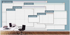
Need Help

Customer Service
Large Chart Sizes
Large Chart Sizes

Get business charts for any size wall,
in sizes ranging from 3x4 to 9x12 feet!
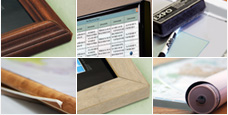
Finishing Option
Finishing Options

Choose from laminated, mounted, framed and magnetic finishing options
to fully display your business charts.

Publisher Logos MarketMAPS National Geographic GeoNova GraphiOgre Rand McNally Map Resources Thomas Brothers Maps Hema Maps Mapsco Maps.com Wide World of Maps Equator Maps Outlook Maps
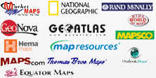
Leading Map Publishers

Leading Publishers - Get quality charts and maps from leading publishers, and customize them by adding your business name & logo!